Local government in London was in a very disorganized state by the middle of the nineteenth century. The new suburbs which had grown up around the City of London were managed (or mismanaged) by the vestries of over ninety parishes situated in the three counties of Kent, Middlesex and Surrey. The epidemics of cholera in 1832 and 1849 and of typhus in 1837-8 had emphasised the urgency of constructing a new system of main drainage and this was the main stimulus for the creation of the Metropolitan Board of Works, brought into existence by the Metropolis Local Management Act 1855. The act also reformed the system of local administration through the creation of elected vestries and district boards of works. The latter were groupings of the more sparsely populated parishes.
The outcome was very usefully summarized by Professor David Owen in his very fine work, The Government of Victorian London 1855–1889, the Metropolitan Board of Works, the Vestries, and the City Corporation (Harvard and London, 1982):
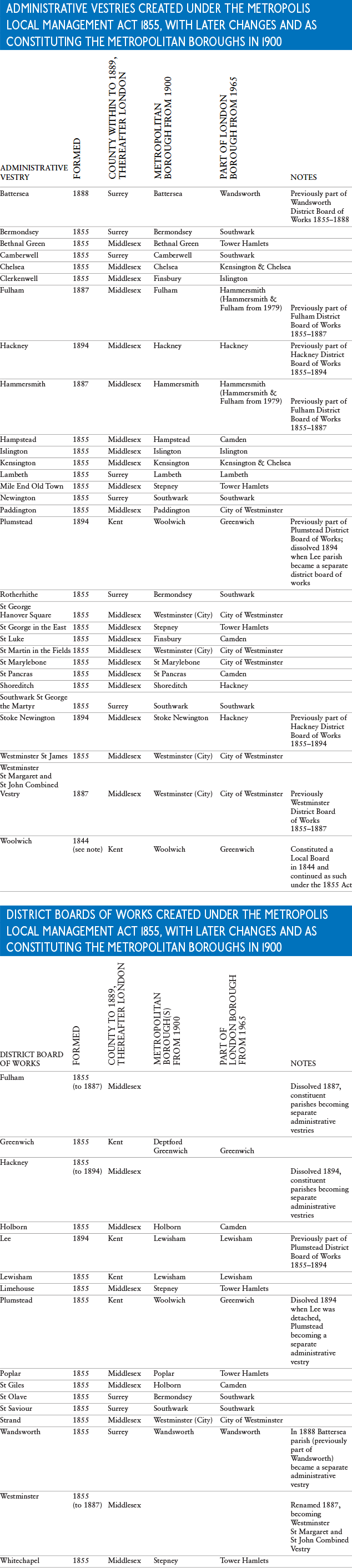
Metropolitan vestries in the age of the Metropolitan Board of Works were a motley lot. Their most conspicuous characteristic was their almost infinite variety – in area, population resources, and organization. The Metropolis Local Management Act of 1855 had served to rationalize in some degree the chaos of parish government, but it had by no means established a uniform policy throughout London. The act recognized as district authorities the elected vestries of twenty-two parishes, and to cover the other fifty-six parishes it set up fifteen district boards of works, each acting for a group of parishes and elected by their vestries. There were, in short, some thirty-eight local authorities in the metropolis, in addition to the City Corporation and a number of extra-parochial units, such as the Inns of Court and the Charter House. The act also wiped out the old mass of paving and lighting boards which had carried on their business quite independently of the parish vestries, and after 1855 their duties became the responsibility of the vestries and district boards.
The act, however, made no attempt to interfere with parish boundaries, so that even the twenty-two large parishes in each of which the vestry served as the local authority showed enormous variations in size. North of the river, Islington (3107 acres or 1257 hectares) had the greatest area; to the south, Camberwell (4332 acres or 1753 hectares), though in mid-century still sparsely settled, was the largest. At the other extreme, St James’s, Westminster, the smallest of the twenty-two parishes, accounted for only 162 acres (66 hectares). In some sections, especially in the older quarters, the parish boundary lines were totally irrational. St Martin’s-in-the-Fields, for example, surrounded St Paul’s, Covent Garden, so that it was impossible to get from St Paul’s to any other parish without crossing St Martin’s. St Margaret’s, Westminster, and St George’s, Hanover Square, intermingled in a most confusing way; while Chelsea had a detached portion at Willesden.
Owen appears to have miscounted, in that there were originally twenty-three vestries in 1855, not twenty-two. In addition, certain other extra-parochial bodies still remained, including nineteen Boards of Library Commissioners and twelve Boards of Baths and Washhouses Commissioners.
The Metropolitan Board of Works itself carried out many important structural and civil engineering projects. In addition to Bazalgette’s main drainage scheme can be added the Victoria Embankment and new roads such as Charing Cross Road, Shaftesbury Avenue and Queen Victoria Street. However, as time went on rumours of corruption and jobbery within the Board (which was indirectly elected) became harder to fend off and led to increasing calls for reform. The Local Government Act 1888 (effective 1889) applied across the UK but almost as an afterthought one of its provisions was the creation of the Administrative County of London which replaced the Metropolitan Board of Works.
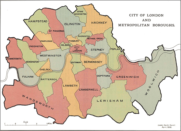
The assumption of overall control by the London County Council in 1889 did not affect the vestries and district boards which carried on much as before for another ten years. There were some adjustments from time to time, two district boards of works being dissolved and one renamed, so that at the end there were twenty-nine administrative vestries and twelve district boards of works. Steadily, though, public opinion was turning against the system of vestry rule with its unsatisfactory electoral and voting arrangements. The London Government Act 1899 (effective 1900) replaced the vestries, district boards and the extra-parochial bodies with twenty-eight Metropolitan Boroughs with a much wider electorate than previously. The only boundary changes were minor so that in most instances the boroughs followed the lines of their predecessors, though there were some mergers of the smaller parishes. The new boroughs were given the same powers of promoting and opposing bills in parliament as the county boroughs, so that in this they were no different from many of the most important cities in the country, such as Birmingham or Newcastle upon Tyne. |